
Fundación ProAves – por la conservación en el país de las aves

Categorías
Tourism Uncategorized @en

Chamicero de Perijá ProAves Reserve

botón Ingles

Perija

The Chamicero del Perijá Bird Reserve was created on January 28, 2014, in order to preserve one of the most fragile and important sites of Colombia, the Serranía del Perijá, habitat for a large number of animal species
and unique plants.
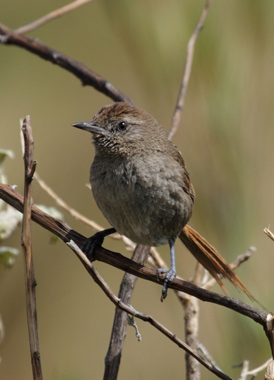
Asthenes perijana2_webpage
Chamicero del Perijá (Asthenes Perijana)

Location and Area:

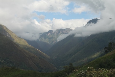
The Reserve is located in the villages of El Cinco and Altos de Perijá, in the municipality of Manaure, department of Cesar, approximately 36 miles from the city of Valledupar. The Reserve has an area of approximately 1850ac. of high andean forests, subparamo and paramo.

Biological importance:

The area has a high number of endemic species of fauna and flora which are threatened with extinction; also conserved forests benefit from the species of birds endemic to the upper and middle sections of the Perijá: Perijá metaltail (Metallura iracunda), The Perija Thistletail (Asthenes perijana), Perijá brush finch (Arremon perijanus) Black-fronted Nunbird Monasa (Atlapetes nigrifrons) and Tapaculo Perijá (Scytalopus sp) a new species recently discovered.

Hydrography

The western sector of the reserve is located on the river basin Manaure which is vital to the town of Manaure, Cesar; many water bodies are third and fourth grade Manaure River tributaries and a few others are vital for aqueducts in the sector of Cinco and El Venado.

Climate:

The area has an average temperature of 59°F and a distribution of rains bimodal climate with four seasons; the total annual rainfall is 1247 mm and close to the multi-year monthly average is 104 mm; periods of increased rainfall occur between April and June and September to November, October is the month with the highest rainfall (163 mm). Dry periods are December to March and June to August, January is the driest month (32 mm)
perija_land


Ecosystem:

The reserve protects subtropical forests (mist) of the Andean and
sub-Andean zones, subpáramos (2600-2900 m) and páramos (3000-3500 m).
The sub-Andean forests are mainly between 1700-2300 m elevation and
Andean about 2,300 m.

Vegetation:

The reserve is made up of forests in different successional stages in the High Andean and sub-Andean bands. In the high Andean (2800-3000 m) band in sites with higher degree of conservation forests dominated by high Hesperomeles ferruginea (association Ilici sessiliflorae – Hesperomeletum ferruginae) have become established with a lower tree layer  elements with heights between 12 and 25 m) dominate coverage and values Importance Values Index (IVI) for Prumnopytis montana, Clusia multiflora, Ternstroemia meridionalis, Podocarpus oleifolius,
Weinmannia pinnata and Hesperomeles ferruginea.

In areas where human intervention is well advanced, scrubby forests dominated by Weinmannia pinnata, Podocarpus oleifolius andBrunellia integrifolia, are stunted elements. In the open páramo vegetation in the northern part of the mountains, the Páramo El Avión (between 3100 and 3400 m) scrub vegetation dominated by páramo bambooand a species of chite are established. Associations including the alliance are: Espeletio perijaensis-Chusqueetum tesse- llatae (chuscal-frailejonal); Arcytophyllo nitidae-Calamagrostietum Intermediae (scrub-grassland) and Geranio holosericeae – Plantaginetum sericeae (meadows). COLOMBIA DIVERSIDAD BIÓTICA V La alta montaña de la Serranía de Perijá. J.O. RANGEL-CH. 2007

Biodiversity:

The Reserve has some important values at the level of both faunal and floral biodiversity. According to studies by the National University in the area 177 vascular plant species have been recorded representing 46% of all species in the mountains of Perijá. In terms of wildlife 4 species of amphibians, 130 species of birds, 23 species of mammals (flying and non-flying) and 54 species of butterflies have been recorded.
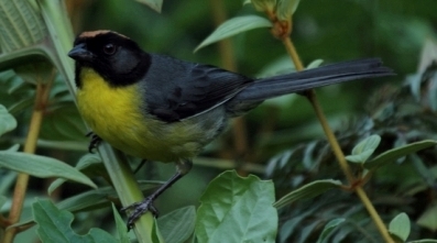
Atlapetes_pal otro lao
Gorrión Montes de Perijá (Atlapetes nigrifrons)

Important species for conservation:

Among the species of flora and fauna of importance for its threatened
status and endemism found 5 species of birds: the Perijá metaltail (Metallura iracunda), The Perijá Thistletail (Asthenes Perijana), Perijá Brush-finch (Atlapetes nigrifrons) and Tapaculo Perijá (Scytalopus sp) a recently discovered new species. And 32 species of flora of interest to the area, 19 endemic and near-endemic restricted to the Colombian side and 13 that are shared with Venezuela were recorded.

Conservation:

Eradication of exotic species, ecological restoration.

Research:

Monitoring of threatened and endemic species.

Facilities:

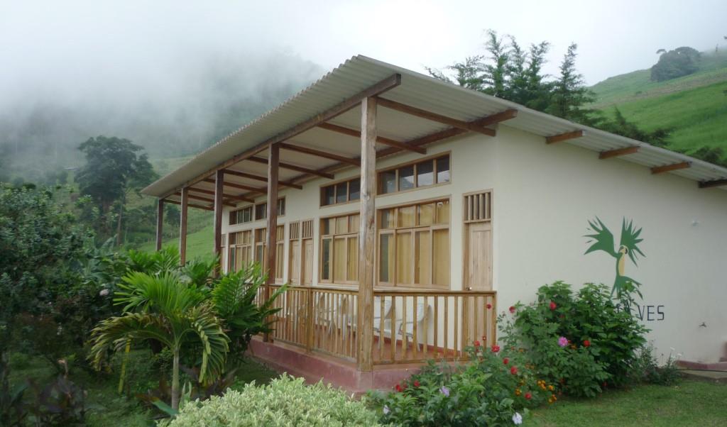
There is accommodation for 10 people, in modern and comfortable cabins with electricity, running water and cell phone signal.s.

Tourist attractions:

Observation of scenic beauty; the snowy peaks of the Sierra Nevada de Santa Marta, the blonde savannah and imposing hill scenery is displayed; you can hike and do bird watching.

General recommendations:

* Respect the natural values of the reserve, plants and animals.
* The collection of biological materials is not allowed.
* Follow directions the reserve staff and travel on established trails.
* Within the reserve camping is not allowed.
* Must bring coats for the cold, Pantanal and waterproof boots.

Reserve your visit NOW:
Email visit@conservation.co or make an online reservation immediatelywww.conservation.co

botón Ingles

Supported by


rain+icfc

Categorías
Noticias Reinita Cielo Azul Noticias Reservas Tourism

Reinita Cielo Azul ProAves Reserve

Establecimiento:

La Reserva Natural de las Aves Reinita Cielo Azul fue creada en el mes de julio del año 2005, con la intención de conservar una muestra de hábitat para el ave migratoria Reinita Cielo Azul (Setophaga  cerulea), siendo la primera reserva nacional y suramericana que se crea con el objetivo de conservar un ave migratoria.

Guía para visitar Reservas

Ubicación y Área:

La reserva cuenta en la actualidad con 207.6 hectáreas de bosque húmedo tropical. Se encuentra ubicada sobre la vertiente occidental de la Cordillera Oriental colombiana en el municipio de San Vicente de Chucurí, departamento de Santander, junto a la serranía de los Yariguíes. La distancia de la reserva al centro poblado más cercano es de 7 kilómetros. Su rango altitudinal está entre los 1600 hasta los 2500 m.s.n.m. Está declarada por la Alianza para la Cero Extinción como un sitio AZE. (Ver mapa).

Cómo llegar:

La Reserva está ubicada en el municipio de San Vicente de Chucurí, departamento de Santander, a 87 Kilómetros de Bucaramanga, tiempo aproximado de viaje 2 horas 20 minutos desde Bucaramanga.

En la Terminal de Transporte de Bucaramanga, se dirige al módulo 1 donde debe tomar un bus de las empresas Coopetran o Cootransmagdalena, los cuales salen a San Vicente de Chucurí cada hora desde las 6:00 am hasta las 7:00 pm, el costo del pasaje es de $20.000 aproximadamente dependiendo de la temporada. Se sugiere que en épocas de invierno, antes de salir, se comunique con el tránsito municipal a la línea 127 para informarse sobre el estado de las vías, pues debido a los derrumbes, pueden cerrar la vía por tiempo indefinido.

Desde San Vicente de Chucurí se debe tomar un transporte hasta la Reserva, las opciones de transporte son: Camioneta 4×4 se debe buscar en el parque principal en la esquina de la droguería la Alemana, con un costo de $60.000 o $70.000 para máximo 4 personas o Mototaxi ubicados en todo el parque principal con un costo de $20.000 por persona.

Si no se tiene un transporte previamente solicitado, le sugerimos comunicarse con una semana de anticipación para reservarlo.

Si cuenta con carro particular, desde Bucaramanga debe coger la vía hacia Barrancabermeja por el sector denominado como Lebrija. A 20 minutos de recorrido, encontrará un desvío a mano izquierda para coger la vía hacia San Vicente de Chucurí, desde este punto el recorrido es de 2 horas. Cuando esté en el pueblo (parque principal), debe coger la vía que conduce a la vereda La Germania (sugerimos que este trayecto se haga únicamente en camioneta o camperos, el uso de automóviles se restringen por la dificultad de la vía). En el trayecto encontrará la señalización para llegar a la reserva.

Importancia biológica:

Entre las aves registradas en la zona están la Perdiz Santandereana (Odontophorus strophium), el Inca negro (Coeligena prunellei), la Amazilia Buchicastaña (Amazilia castaneiventris), el Torito Dorsiblanco (Capito hypoleucus), el Hormiguero de Parker (Cercomacra parkeri), el Tapaculo Ratón (Scytalopus latebricola), el Tordo Montañero (Macroagelaius subalaris) y el hormiguero pico de hacha (Clytoctantes alixii). Asimismo es posible ver anfibios como la Rana Venenosa (Myniobates virolinensis) y mamíferos como el Oso de Anteojos (Tremarctos ornatus).

Descarga la lista de aves completa en pdf. 

Clima:

Registra una temperatura entre los 16 y los 28 º C.

Conservación:

Restauración ecológicaCafé Amigo de las AvesServidumbres ecológicas, Silvopastoril, Mujeres por la conservación y Corredor de conservación reinita cerulea

reinita
Reserva Natural de las Aves Reinita Cielo Azul

Instalaciones:

Capacidad de alojamiento para 25 personas.

Atractivos turísticos:

El principal atractivo turístico está constituido por la observación de la vida silvestre de la zona, principalmente de aves y mamíferos, asimismo caminatas por el histórico sendero de Lengerke, construido en piedra en el año de 1840 por el alemán Geo Von Lengerke, con una longitud de 40 kilómetros y que conduce desde el municipio de San Vicente hasta Zapatoca.

Recomendaciones generales:

  • Respetar los valores naturales de la reserva, las plantas, y los animales.
  • No se permite la colecta de material biológico.
  • Seguir las indicaciones del personal de la reserva y circular por los senderos establecidos.
  • Llevar repelente, bloqueador, botas pantaneras y accesorios para protegerse del sol.
  • Informar sobre problemas de salud y/o alergias.
  • Desinfectar calzado con hipoclorito o clorox para prevenir la dispersión del hongo quitridio (una de las principales causas de muerte de anfibios en el mundo).

Ingreso y visitas:

Escriba a info@proaves.org 

Categorías
Tourism

El Paujil ProAves Reserve


The El Paujil Bird Reserve was created in November 2003 in order to preserve the Blue-billed Curassow (Crax alberti) is endemic to Colombia and in critical danger of extinction, while ensuring the preservation of one of the most vulnerable ecosystems which had been circulated in the Middle Magdalena valley, the rain forest.

inicio_web_paujil
Blue-billed Curassow (Crax alberti)

Location and Area:

This protected area is located in the Sierra de las Quinchas, between the towns of Puerto Boyacá, Bolívar and Scimitar, more precisely in the departments of Boyacá and Santander, respectively, it covers 8.448 acres and is located between 150 and 1.200 m.s.n.m. (See map).

Biological importance:

There has been about 360 species of birds registered in this place , 7 of which are endemic species, 8 threatened near-endemic and 8 threatened, 43 non-flying mammal species of which 18 are threatened, 24 species of flying mammals, 32 species of amphibians 1 of which is threatened and 46 species of reptiles. It also highlights: the Cotorra cabeciamarilla (Gypopsitta pyrilia), Carpintero bonito (Melanerpes pulcher), White-Mantled Barbet (Capito hypoleucus), Tiranuelo antioqueño (Phylloscartes lanyoni), Habia ceniza (Habia gutturalis), Mielero turqueza (Dacnis hartlaubi) Mono araña del Magdalena (Ateles hybridus), el Oso andino (Tremarctos ornatus) y Nutria del Magdalena (Pteronura longicauda), among others.

Download the complete list of birds in pdf.

Climate:

The reserve has an annual temperature of 27.8 ° C. The rainfall is bimodal seasonal tetra. The first period of rainfall occurs between April and May and the second between September and November, during these five months, receiving 57.62% of total rainfall, with October the wettest month with 304 mm and the driest January to 64.5 mm The average relative humidity is 78%, ranging from 75% in February and August, and 81% in October and November (Balcazar et al. 2000).

Biophysical characteristics:

Consists of primary and secondary forests little surgery, pastures and plantations.

Condition:

Ecological restoration, Land expansion and Women for conservation.

And tourism activities:

  • River navigation.
  • Landscaping.
  • Wildlife photography.
  • Observation of animal and plant species.
  • Walking in high demand.
  • Contact recreation and nature.
  • Family vacation.
  • Recreational fishing.
  • Enjoy natural scenery (Caño cristal, La moya, Pozo lindo and Los chorros).
  • Reforestation of native species.
  • Eco-hikes.
  • Horseback riding.
  • Courses and training.

 Facilities:

Accommodation for 43 guests in comfortable cabins, electricity service and water.

General recommendations:

  • Respect the natural values of the reserve, the plants and animals.
  • Do not allow the collection of biological material.
  • Follow signs to the reserve staff and travel on established trails.
  • You can make camping in designated areas.
  • Wear rubber boots.
  • Report health problems or allergies.

Reserve your visit NOW:
Email: visit@conservation.co or make an online reservation immediately:  www.conservation.co

botón Ingles

Categorías
Tourism

Colibrí del Sol ProAves Reserve

botón Ingles

Establishment:

In order to protect the habitat of the Dusky Starfrontlet (Coeligena orina) and conserve a sample of one of the moorland ecosystems in the best state of preservation in Colombia, ProAves established the Dusky Starfrontlet Bird Reserve on 6th October 2005.

Coeligena_orina
Colibrí del Sol (Coeligena orina)

Location and Area:

It is located in the village of El Chuscal, on the axis of the Cordillera Occidental, at a distance of 17 km north of the town of Urrao, Antioquia, and has an area of 1.801 acres of high Andean forest and moorland, which comprises a large portion of the watershed of the creek Santa Barbara, one of the main tributaries of Urrao. It is located between 2,800m and 4,060m above sea level. (See map).

Biological Significance:

Some species of birds found in the reserve are the Dusky Starfrontlet (Coligena orina), critically endangered, Rusty-faced Parrot (Hapalopsittaca amazonina), the Chestnut-bellied Flowerpiercer (Diglossa gloriosissima), The Moustached Antpitta (Grallaria alleni), in a vulnerable state, and Golden-crowned Tanager (Iridosornis rufivertex).

Recently, at the reserve, was discovered a new species of Grallaria, known as Urrao Antpitta (Grallaria fenwickorum). Moreover, the site is recognized as an area of labor and training or Spectacled Bear (Tremarctos ornatos), which holds the vulnerable category.

Download the complete list of birds in pdf.

Climate:

The climate is bimodal, with rainfall ranging between 2,500m and 3,000 mm and a minimum temperature of between 2 and 18 º C.

Biophysical Features:

The reserve is composed of oaks (Quercus humboltii) in good condition and mixed forest epiphytes. Above 3,500 m., the moorland presents associations, including the endemic Frailejón  de Frontino (Espeletia frontinoensis) and chaparrales dominated by associations of (Polylepis quadrijuga). Its terrain is predominantly mountainous, with about 70% of the area with steep slopes, 20% hills and 10% flat. The soils have Andic, high porosity, medium textured, moderately well-structured and highly acidic properties.

As for flora, for the area 450 species belonging to 247 genera included in 136 families of fanerogamas and Cryptogamas have been reported. Among them was found a new species of Asteraceae, which was described by Cuatrecasas as Espeletia frontinoensis.

Dusky Starfrontlet Reserve

Conservation:

Ecological easements y Restoration, reforestation programs of the Páramo del Sol, páramo conservation plan of the Páramo del sol and Artificial nests program.

Research: 

Monitoring Migratory Bird, evaluation of the Dusky Starfrontlet population status, monitoring the Rusty-faced Parrot (Hapalopsittaca Amazonina).

Education:

Bird friendly Schools and Parrot Bus.

Facilities:

Capacity of accommodation for ten people; electricity and potable water.

Tourist Attractions:

Belleza paisajística, avistamiento de aves amenazadas, Eco ruta del Sol, mirador Páramo del Sol y sendero Rusty faced, bebederos para colibríes y comederos para Grallaria – Tororoide urrao (Grallaria fenwickorum).

General recommendations:

  •  Being a wilderness area Pantanal boots it is nescessary to bring jackets, gloves, sunscreen, waterproof sleeping.
  • Respect the natural values of the reserve, plants, and animals.
  • The collection of biological material is not allowed.
  • Follow the instructions of the reserve staff and travel on established trails.

Reserve your visit NOW:
Email: visit@conservation.co or make an online reservation immediatelywww.conservation.co

botón Ingles

Categorías
Tourism

Las Tángaras ProAves Reserve


logoTangaras

Las Tángaras Bird Reserve was created in October 2009 to protect the habitat of two endemic bird species: The Golden-ringed tanager (Bangsia aureocinta) and the Black-and-gold tanager (Bangsia melanochlamys). The Municipality Carmen de Atrato signed the memorandum of understanding to be part of the Alliance for Zero Extinction Colombia in October 2010.

Tangara
Black-and-gold tanager (Bangsia melanochlamys)

Location and Area:

Las Tangaras Bird Reserve is one of the most diverse and important tropical forest sites on earth, and will protect a great elevational gradient – from 1,250 to 3,400 meters above sea level. This area protects the watershed of the Rio Atrato – the Chocó’s most important river which serves as a vital economic resource for tens of thousands of inhabitants living in poor rural communities. This strategic land acquisition helps consolidate a buffer zone protecting over one hundred thousand acres, against unsustainable rapid colonization, and strengthens the protection of several isolated indigenous communities threatened by colonization. This location became the target area for creating a new reserve. A total of sixteen private properties in the area were immediately acquired to create the 7,076 acre Tanagers Reserve.

Download the complete list of birds in pdf.

Weather:

Located in an area dominated by mist and precipitation throughout the year, the annual temperature varies between 8 ° C and 23 ° C, with an annual rainfall greater than 4000 mm.


Tangaras
Las Tángaras Lodge

Hydrography:

Many water sources are born in the area, highlighting the Quebrada La Sanchez, a tributary of the Rio Atrato.

Biodiversity:

In regards to flora the presence of numerous epiphytes and orchids (gen. Epidendrum sp.), are to be noted. Large trees like encenillo (Weinmanniasp) and aguacatillos (Ocota sp.) stand out among others.

It has a high diversity index with records of 250 species of birds belonging to 15 orders and 42 families, highlighting the Golden-ringed tanager (Bangsia aureocinta) the Black-and-gold tanager (Bangsia melanochlamys), the Chocó Vireo (Vireo Masteri), the Purple-mantled Tanager (Iridosornis porphyrocephala), the Indigo Flower-Piercer (Diglossa Indigotica) and Fulvous-dotted Treerunner (Margaronis stellatus) and several species of hummingbirds like the Brown Inca (Coeligena wilsonii), Velvet-purple Coronet  (Boissaneaua Jardini) and Empress Brilliant (Heliodoxa imperatrix)

In Amphibians, specimens of the families, Centrolenidae, Bufonidae and Stabomantidae, are often found, the presence of salamanders of the genus Bolitoglossa stand out.

Cultural Significance:

The reserve is located close to Afro-Colombian and indigenous cmmunity reserves. The Embera, Embera Chami and Dovida peoples are important cultures of the area.

Biophysical Features:

Some of the ecosystems found in the area are: humid forest, wet forest and lower montane forest.

Facilities:

The Lodge has accommodation for 20 people with modern and comfortable cabins, along with 24-hr electricity, potable and hot water. Phone and internet connections.

Tangaras_2
Las Tángaras Reserve

Attractions:

The scenic beauty of the area is unparralled. Birdwatching is a favorite activity but also hiking and nature observations are available.

General Recommendations:

  • Wear cold weather clothing, rubber (welly) boots, insect repellent, sunscreen and sun protection accessories.
  • Please advise about health problems and food allergies.
  • Respect the natural resources of the reserve. The collection of biological material is not allowed.
  • Follow instructions from the reserve staff and stay on established trails.
  • Disinfect shoes with Clorox or bleach to prevent the spread of the chytrid fungus (one of the leading causes of death in amphibians around the world).

Reserve your visit NOW:
Email:  visit@conservation.co or make an online reservation immediately:  www.conservation.co

botón Ingles

Categorías
Tourism

Arrierito Antioqueño ProAves Reserve


botón Ingles


The Chestnut-capped Piha Bird Reserve was created to protect the habitat of Chestnut-capped Piha (Lipaugus weberi), on 27 November 2006. It has an area of approximately 3.271 acres and is classified according to the Alliance for Zero Extinction as an AZE site. It is located in the El Roble, Anorí (Antioquia), with an altitude between 1,400 and 1,850 m above sea level.

Arrierito
Chestnut-capped Piha (Lipaugus weberi)

Location and Area:

The Chestnut-capped Piha now survives only in small forest fragments in the Central Cordillera of the Andes because their habitat was much affected in the early twentieth century by gold mining and later by large-scale deforestation for the establishment of pasture the reserve is of great importance to its care. (See map).

Biological importance:

You can spot the Black Tinamou (Tinamus osgoodi), Sharpbill (Oxyruncus cristatus), the Stiles’s Tapaculo (Scytalopus Stilesi), the Parker’s Antbird (Cercomacra parkeri), the Bicoloured Hawk (Accipiter bicolor), the Red-bellied Grackle (Hypopyrrhus pyrohypogaster) Multicolored Tanager (Chlorochrysa nitidísima), the Black-and-gold Tanager (Bangsia melanochlamys) and Cerulean Warbler (Dendroica cerulea), a migratory species that visit the reserve in non-breeding season.

Download the complete list of birds in pdf.

Climate:

Protects a sample of pre-montane rain forest and it has a bimodal climate, with temperatures averaging 18 º C.

Biophysical characteristics:

Consists of primary forests, secondary forests and grasslands undergoing some regeneration. Predominantly its relief is mountainous, with about 60% of the land with slopes, 30% hills and 10% flat.

As for frogs, there are seven vulnerable species, four endangered and five that have not yet been formally described; it is believed that at least one of them belongs to one of the most threatened groups of frogs, of the genus Atelopus, which lives only in this region.

Conservation:

Ecological restoration,Ecological easements and Co-operation.

Chestnut-capped Piha Bird Reserve

Investigation:

Arrierito Antioqueño Project (Lipaugus weberi) and Migratory Bird Monitoring.

Facilities:

Accommodation for 18 people. Electricity and water services. Access to cellular signal.

Attractions:

Trails for bird watching, hiking trails with varying degrees of difficulty, waterfalls, observation of endemic species of fauna and visits to places of old mining activity like tunnels and walls of canyons.

General recommendations: 

  •  Bring cold weather clothing, Pantanal boots, insect repellent, sunscreen and sun protection accessories.
  •  Report on health problems, allergies and eating habits.
  •  If you plan to camp, carrying full camping equipment and plastic to put under it.
  •  Disinfect footwear with bleach or Clorox to prevent the spread of the chytrid fungus (one of the leading causes of death of amphibians in the world).

Reserve your visit NOW:
Email:  visit@conservation.co 
or make an online reservation immediately: www.conservation.co

botón Ingles